New satellite shares STUNNING photo of Earth
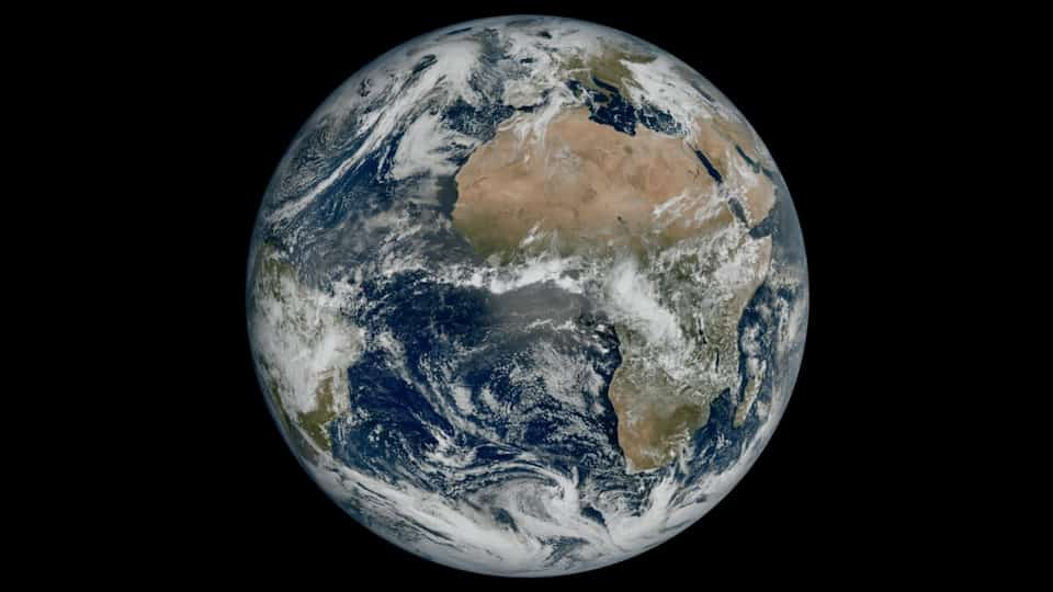
ESA satellite, Meteosat Third Generation Imager, has shared its first-ever view of the Earth, highlighting conditions over Europe, Africa, and the Atlantic in remarkable detail.


The European Space Agency (ESA) launched its Meteosat Third Generation Imager (MTG) satellite on December 13, 2022. ESA stated that the weather satellite can “revolutionize weather forecasting and enable more precise monitoring of our changing atmosphere, land, and oceans” at the time. The satellite recently became operational and it has now shared its first-ever photo of the Earth and it showcases the stunning details over Europe, Attica, and the Atlantic region.
Sharing the spectacular image, ESA said, “The image, which was captured by the satellite's Flexible Combined Imager on 18 March 2023, shows much of Northern and Western Europe and Scandinavia blanketed in clouds, with relatively clear skies over Italy and the Western Balkans”.
ESA shares the first-ever Earth view from Meteosat Third Generation Imager
Launched on an Ariane 5 rocket on 13 December 2022, the Meteosat Third Generation Imager-1 (MTG-I1) is the first of a new generation of satellites set to revolutionize weather forecasting in Europe. ESA and Eumetsat are proud to jointly release the new image from the next generation.
“This image is a great example of what European cooperation in space can achieve. The level of detail MTG-I1's image reveals will give us a greater understanding of our planet and the weather systems that shape it,” said Simonetta Cheli, ESA's Director of Earth Observation Programmes.
The third generation of the Meteosat Imager satellite can take pictures in much higher resolution and at a higher frequency than the previous generation. It is also capable of highlighting details such as cloud vortices over the Canary Islands, snow cover on the Alps, and sediment in the water along the coast of Italy, which are all visible in the image shared by ESA.
The satellite is currently undergoing a 12-month commissioning phase, in which its instruments, the Flexible Combined Imager and the Lightning Imager, are switched on and the data they produce are calibrated. Data from the satellite will then be disseminated to meteorological services in Europe and beyond at the end of 2023, for operational use in weather forecasts.
Catch all the Latest Tech News, Mobile News, Laptop News, Gaming news, Wearables News , How To News, also keep up with us on Whatsapp channel,Twitter, Facebook, Google News, and Instagram. For our latest videos, subscribe to our YouTube channel.


