Google’s Street View is the new environmental watchdog
As world leaders gathered in Paris on Monday in the hope to stopping catastrophic climate change, Google Maps provided online views of remote locations where wildlife is struggling for survival.
| Updated on: Dec 01 2015, 13:20 IST
As world leaders gathered in Paris on Monday, in the hope to stop catastrophic climate change, Google Maps provided online views of remote locations where wildlife struggles for survival.
The Street View feature at the free online map service has grown from just showing a satellite view of business or residential addresses to allowing virtual exploration of mountains, rain forests, ocean depths and more.
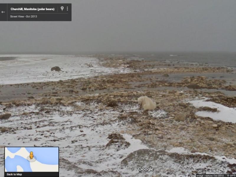
Some settings find creatures in dire straits, such as the polar bear in the Canadian Arctic appearing to desperately wait for bay ice that won't form because temperatures are too high.
"From polar bears in the Canadian Arctic, communities in the Brazilian Amazon, to blue oak trees in Central California, the impacts of climate change are being felt by plants, animals and people across the planet," said Google Earth outreach program manager Karin Tuxen-Bettman.
"With Street View, you can get a window into some of our world's changing ecosystems, and learn how nonprofit and other organisations are working to keep our planet healthy."
Polar Bears International (PBI) borrowed Street View Trekker 360-degree camera and location-pinpointing gear to enhance maps with scenes of polar bears in Manitoba as the sea ice on which they depend vanishes.
PBI incorporated the Street View scenes into its website and a lesson plan for schools to help children learn about the habitat.
Brazilian nonprofit Amazonas Sustainable Foundation (FAS) used Trekker Gear to capture scenes in the Amazon forest and put isolated local communities on the map.
FAS captured imagery from three reserves in the Amazon and uses it to educate about rain forest protection and sustainable ecosystem management, according to Google.
Visualising climate change
The initiatives aims to make climate change more real for people and inspire them to act by allowing virtual exploration of remote areas to witness the beauty lost or under threat due to climate change.
Street View imagery also allows comparisons of changes that environments are going through, along with the climate.
"Street View is great for visualising the impacts of climate change, but we're also using it to measure climate data, which can be used by scientists, policymakers, businesses and citizens to drive better decisions," Tuxen-Bettman said.
Google Earth has worked with the Environmental Defense Fund for years to map methane leaks from natural gas lines (under an array of US cities) by equipping Street View cars with special gear, according to Tuxen-Bettman.
Street View cars will begin measuring more pollutants, such as climate change culprit — carbon dioxide — in an alliance with environmental sensor network specialty firm Aclima, according to California-based Google.
"Essentially, we're turning Street View cars into environmental sensing platforms," Tuxen-Bettman said, noting that they will first be put to work in California communities.
Catch all the Latest Tech News, Mobile News, Laptop News, Gaming news, Wearables News , How To News, also keep up with us on Whatsapp channel,Twitter, Facebook, Google News, and Instagram. For our latest videos, subscribe to our YouTube channel.