How to plan routes with the Measure distance tool on Google Maps
If you are planning routes, here is how to use your smartphone to pick the fastest route using the Measure distance tool on Google Maps
Google Maps has established itself as one of the most widely used navigation services on mobile devices, thanks to the sheer number of Android devices (3 billion as of May 2021) and Google's constant innovation to improve the service. Several iPhone users also download the app on their devices, to take advantage of Google's navigation service.
While navigating using Google Maps is useful if you have a car or bike, or walking through an unknown neighbourhood, it can also be used for several other purposes. These include checking for traffic on your regular route home and looking at alternate routes, checking one-way roads, as well as roadblocks, diversions, and even accidents. However, Google Maps is also useful for another basic feature that many users may not have tried – measuring distances using their smartphone or browser on a computer.
Also read: Looking for a smartphone? Check Mobile Finder here.
How to measure distance on Google Maps on your smartphone
Step 1) Make sure your Google Maps app is up to date, then launch the app.
Step 2) Zoom into your location, then tap to select the ‘starting point' and after holding, the app will display a pin on the map.
Step 3) Select the new popup called “Dropped pin” on the screen, then tap on ‘Measure distance'.
Step 4) Use the target to select the desired location, then select ‘Add point' and check the screen for the distance between your initial location and final destination.
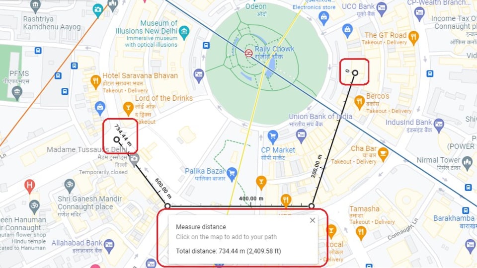
Step 5) For more complex measurements, users can also add ‘points' along the map which will continue to update the distance as new points are added and the service adds the extra distance among them.
How to measure distance on Google Maps on your browser
Step 1) Visit maps.google.com to load the Google Maps service.
Step 2) Place your mouse exactly on top of the place you want to start with, then right-click and choose Measure Distance. This will be your starting point, and you can zoom in to get better accuracy.
Step 3) Simply scroll out, identify the second place on the map, and then click on the location. You can zoom in again for added accuracy, and to select a precise location.
Step 4) Check the bottom of the Google Maps tab, to see a small pop up that shows the distance between the two points.
Step 5) Sometimes, you want to measure more than just the distance between two points - continue clicking on additional locations on the map and the small popup will show the new distance between the original location and the new destination.
Catch all the Latest Tech News, Mobile News, Laptop News, Gaming news, Wearables News , How To News, also keep up with us on Whatsapp channel,Twitter, Facebook, Google News, and Instagram. For our latest videos, subscribe to our YouTube channel.


