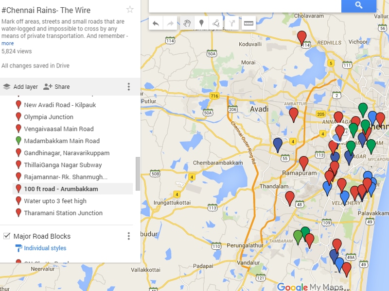
Living in Chennai? Use this map to avoid waterlogged areas
Google maps has come to the rescue of Chennai residents who bore the brunt of the north-east monsoon with office-goers struggling to wade through waist-deep water and local trains running late due flooding of the tracks.
| Updated on: Nov 17 2015, 18:08 IST
Google maps has come to the rescue of Chennai residents who bore the brunt of the north-east monsoon with office-goers struggling to wade through waist-deep water and local trains running late due flooding of the tracks.
A customisable version of Google maps allows the city dwellers to mark off areas, roads and streets that are water-logged and are not safe. It also helps people to find safer alternate roads.
You may be interested in

-
 Obsidian
 - 12 GB RAM
- 128 GB Storage

- Asteroid Black
- 16 GB RAM
- 512 GB Storage

- Black
- 6 GB RAM
- 128 GB Storage


Click here to see the map .
New information can be added to the map by simply clicking on 'add layer' option available in the left side panel.
The Google map was created for public use by http://thewire.in/.
Chennai has been experiencing continuous rains since Saturday night with the spell reduced to a drizzle on Monday.
Several areas, including Mylapore (South Chennai), Vysarpadi and Perambur (North Chennai) have remained inundated since Sunday due to flooding.
Catch all the Latest Tech News, Mobile News, Laptop News, Gaming news, Wearables News , How To News, also keep up with us on Whatsapp channel,Twitter, Facebook, Google News, and Instagram. For our latest videos, subscribe to our YouTube channel.