MAJESTIC! ISRO shares striking images of the Earth from its new EOS-06 satellite
The new ISRO satellite EOS-06 has captured some majestic images of the Earth including a stunning image of India. Check details.

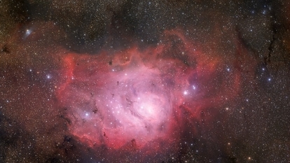
The Indian Space and Research Organization (ISRO) shared stunning images of the Earth captured by its third-generation Oceansat EOS-06 on Wednesday, March 29. The images highlight different regions of the Earth, including India, in an entirely different color spectrum using the Ocean Color Monitor (OCM), a sensor on the satellite. ISRO also revealed that the images are a mosaic generated by National Remote Sensing Center (NRSC) using the data sent by the EOS-06 satellite.
Sharing the images in a tweet from its official Twitter handle, ISRO stated, “Global False Colour Composite mosaic generated by NRSC/ISRO using images from Ocean Colour Monitor on EOS-06. Mosaic with 1 km spatial resolution combines 2939 images after processing 300 GB of data to show Earth as seen during Feb 1-15, 2023. OCM senses the Earth in 13 distinct wavelengths to provide information about global vegetation cover on Land and Ocean Biota for global oceans”.
You may be interested in


ISRO captures stunning images of the Earth
Interestingly, the OCM sensor can capture images in 13 different wavelengths. And this is why the continents on the images appear in red and yellow hues. Every single mosaic is made up of 2939 images which are taken after processing 300 GB of data. The satellite was sent originally to collect data around ocean color and wind.
EOS-06 is a Oceansat-3 series nanosatellite which was deployed aboard the PSLV-C54 mission on November 26, 2022 by ISRO. The satellite has three primary objectives, all around oceanography and atmospheric studies.
Apart from keeping continuity in data concerning ocean color and wind vector, the satellite also collects Sea Surface Temperature and is capable of recording data in more bands in the Optical region for fluorescence and in the Infrared region for atmospheric correction. The data would then be used by applications in related fields.
The satellite has been fitted with four key instruments. First is the Ocean Color Monitor (OCM-3) which played a major role in capturing these images. Second is the Sea Surface Temperature Monitor (SSTM). Apart from that, it also contains Ku-Band Scatterometer (SCAT-3) and ARGOS which helps it in capturing images in different wavelengths.
Catch all the Latest Tech News, Mobile News, Laptop News, Gaming news, Wearables News , How To News, also keep up with us on Whatsapp channel,Twitter, Facebook, Google News, and Instagram. For our latest videos, subscribe to our YouTube channel.
More From This Section